Monday, September 2, 2019

Circles in the Sand


We had a very special experience while we were in Bandon, Oregon. We were lucky enough to be there for one of the few Circles in the Sand events remaining this summer. Denny Dyke is the creator of the Circles in the Sand labyrinth.

A bit about Denny Dyke from the Circles in the Sand website https://www.sandypathbandon.com/
'Labyrinth artist, Denny Dyke first created Circles in the Sand for his own walking meditations.  He soon became fascinated with the ocean and the ever-changing sand.  After three years and hundreds of labyrinths later, the first Dreamfield Labyrinth was created in September 2014.
The path of the first Dreamfield meandered through seven spirals and returned near the entrance.  Today the Dreamfields have grown larger with a path meandering through a much larger pattern.  Always with one path, no dead ends or no wrong turns and returning home.  A true labyrinth experience on the sand.'


I'm not sure what time Denny and his team began the labyrinth, sometime after the tide went out, but the walking time was from 8AM to 10AM. After 10AM the tide started to come in and erase the labyrinth.

This photo is from the overlook, showing the scope of the labyrinth.


We walked down a series of staircases to get to the beach. Before beginning the walk, Denny introduced his team and welcomed us to enjoy the walk. He's second from the left in the photo below.


This was a magical experience, hopefully the photos can convey some of that sense of wonder and showcase the amount of work that went into this labyrinth.


This gentleman is the Bubble Man, and evidently he comes to many of the labyrinths. He told me that his daughter makes her living traveling all over the world doing bubble art, and that her largest bubble enclosed an elephant. Yikes!


After experiencing the labyrinth we did some further exploring and had lunch. We returned in the afternoon to see how our Circles in the Sand were doing.


Pretty much gone with the tide. It boggles my mind that Denny and his crew spend so much time and are so creative, just to share a bit of peace and joy with the world. He says that the energy from the labyrinth goes back to enrich the sea.

Here is another link in addition to the one I mentioned at the beginning of this post  https://www.sandypathbandon.com/ that also has a beautiful video.


Monday, August 26, 2019

Washington's Olympic National Park

Olympic National Park on Washington's Olympic Peninsula has an incredible range of diversity. It covers nearly a million acres and has three distinctly different ecosystems - glacier-capped mountains, an old-growth temperate rain forests, and over 70 miles of coastline. We have been to all three regions in previous years, and spent most of our time in the Hoh Rain Forest and Rialto Beach this time around.

The Hoh Rain Forest

The Hoh Rain Forest is lush, mossy, and full of old growth trees. Some of them can reach over 300 feet high and seven feet in diameter.


Most of the trees are covered with huge clumps of hanging moss, ferns and fungi.


While Seattle gets around 36 inches of rain a year, the Hoh Rain Forest gets as much as 14 feet of rain a year. The prevalent fog and mist contribute the equivalent of another 30 inches of rain, resulting in one of the world's lushest rain forests. It has been awarded the distinction of being a World Heritage Site and a Biosphere Reserve by UNESCO.


There were numerous examples of what are called 'nursery logs'. These are trees that fell, and as they decayed seedlings and other trees began to grow on them. The roots of the seedlings often straddle the log as they grow toward the soil.


Rialto Beach

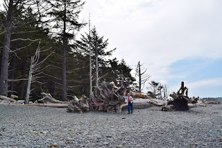
Rialto Beach always leaves us speechless. The driftwood trees are incredibly huge, as are the trees growing next to the beach. It's a very different, stunning beach.


There are sea stacks off the beach. A sea stack is a geological landform consisting of a steep and often vertical column or columns of rock in the sea near a coast, formed by wave erosion. It's amazing how trees manage to grow on them considering the harsh conditions. We were surprised when the owner of the RV park we were staying at near Rialto told us that they are very busy during the months of January and February. Evidently people love to come here to experience the winter storms. Judging by what's left on the beach by the storms they must be amazing.


More seastacks in the distance off the peninsula.


Brian got to be the model for the day to put things into perspective.


This tree's roots make it look like they're about to add another log to the beach, which could take who knows how many years.

Tuesday, June 25, 2019

Kasha-Katuwe Tent Rocks National Monument

While we were in Santa Fe, NM  a few weeks ago we were looking for some places to hike and found out about Kasha-Katuwe Tent Rocks. The National Monument was about 30 miles from our RV park in Santa Fe, so pretty easy to get to. It was kind of a mini Bryce Canyon, only the hoodoos were a different color.

Tent Rocks is jointly managed by the Bureau of Land Management and the Pueblo de Cochiti, which has always considered this to be a sacred place. Kasha-Katuwe means white cliffs in the Keresan language of the pueblo.


The cone shaped tent rock formations and hoodoos were formed from volcanic eruptions and were carved by wind and water. Some of the hoodoos have boulder caps that protect the softer area below, but those that have lost these caprocks are disintegrating. The photo above shows the hoodoos with the caprocks, and the photo below is of the ones that no longer have caprocks.


There are two hiking trails at Kasha-Katuwe, both starting at the parking area. The Canyon Trail is 1.5 miles long, and is the one we took first. It goes through a  canyon and climbs 630 feet to the top of the mesa. 
Having Brian in this photo gives some perspective to the size of the hoodoos.


 It's hard to believe the tree below has survived the water that must rush through the canyon.


The root system was incredible.


There were spots on this hike where the canyon was more of a slot canyon. It was so narrow in places that we had to go single file and take turns with people going in the opposite direction. While waiting for one group to come through I overheard a young boy ask his mother 'do only old people use those poles?' Very observant of him.

Fun to look up through the narrow slots.


After hiking the Canyon Trail we took the 1.2 mile Cave Trail. The one cave we saw had drawings on the ceiling. Not sure how old it was, but we learned that during the 14th and 15th centuries several large ancestral pueblos were established and their descendants, the Pueblo de Cochiti, still inhabit the area.


The trail back to the parking area wound around through the tent rocks and hoodoos.


We've been to Santa Fe quite a few times, but this was the first we had heard of Kasha-Katuwe. It's always fun to discover new places!

Thursday, March 21, 2019

Big Bend National Park is BIG


Brian and I have wanted to stop at Big Bend NP on our way back from Mexico for several years, partly as part of our quest to see as many national parks as possible and also because of its featurs. Big Bend is one of the largest, most remote, and one of the least-visited national parks in the continental United States, but it's still difficult to get a campground reservation there.
One of the main attractions are the hiking and backpacking trails. Big Bend is also known for its dark skies and stargazing.In 2012, the park was designated an international dark-sky park by the International Dark-Sky Association. Measurements made by the National Park Service show that Big Bend has the darkest skies in the continental United States. Thousands of stars, bright planets, and the Milky Way are visible on clear nights. Unfortunately we were there during a full moon with cloud cover so we weren't able to get the whole dark sky experience.

Big Bend is very popular during early spring so we've never been able to get a campground reservation and boondocking isn't allowed in the park. Since it's so vast and off the beaten path it only made sense to us to go if we could get into one of the campgrounds. There are only two campgrounds in the park that will accommodate rigs over 24 feet so our choices were limited unless we wanted to stay outside of the park and spend half our day driving into and out of the park. We got lucky this year and were able to reserve two consecutive nights, the only ones available in February or March.


The map above shows how far the Park Headquarters and Visitors Center are from the closest towns (which aren't exactly close to anything else). We stayed at the Rio Grande Village Campground which was 30 miles from the Visitors Center. On the map above it's located where the road from the Visitors Center goes southeast and ends at the Rio Grande River.

Big Bend covers 1,251 square miles and there aren't very many maintained roads so it takes a while to get around. The roads in the park end at the Rio Grande River, which is the boundary between the United States and Mexico. More than 1,000 miles of the river are part of the boundary and 118 miles of that are in the park. Many of the park's features have been shared with Mexico for thousands of years. Santa Elena Canyon, one of the park's best known and most photographed features is half a canyon in the U.S. and half a canyon in Mexico, and the Chihuahuan Desert is shared by both countries.

We spent our time on our first day exploring the area around the campground. We drove out to the Boquillas Canyon overlook where visitors often cross to visit the Mexican village of Boquillas. In the photo below the plateau is in the U.S. and Boquillas is in Mexico. It's a good example of how much the river bends, pun intended.


We continued on to Boquillas Canyon and hiked into the canyon. The Rio Grande begins in south central Colorado and flows to the Gulf of Mexico. Much of the water is diverted before the river reaches Big Bend.


Boquillas Canyon is one of three major canyons in the park. Although the water level was low, it was still impressive to see the canyon walls and rock formations. The woman walking into the canyon in the photo below gives some perspective of how high the canyon walls are. We enjoyed the hike although it was super hot - wrong time of day to be hiking but it was our only chance so we took it.


Santa Elena is the most well-known canyon and it was our first destination on our second day. We got up early to make the drive, well over an hour from our campground, in an effort to beat the heat and other hikers. Good decision, and it worked out well. The canyon is spectacular.


We hiked a trail that followed the river, ascending at the beginning before coming back down to water level. The photos above were taken at the entrance to the canyon, looking both ways.


We saw several groups of people canoeing the canyon.


From what we could determine, canoeing on the river is allowed as long as one has a permit. It appeared there were places to camp upriver. When we saw a large group of people returning downriver with a guide we checked things out and found that there are several companies that are licensed to escort river trips.

Big Bend has several ecosystems - river, desert, and mountain. After leaving Santa Elena canyon we headed for the mountains. Not mountains by Colorado standards but definitely not desert. The elevation in Big Bend ranges from 1800 feet to 7832 feet so maybe these could be called mountains.


We had a fun, if tiring few days and saw a limited amount of Big Bend. It would take more than a few days to see it all but I think we got a pretty good idea of what it has to offer.